Do I Live In A Watershed?

YES, no matter where you live, country – suburb –city – you live in a watershed and you have an impact on its future and it has an impact on you. Every drop of water that flows from your faucet is a product of a watershed. Every time you drive a car or ride a bus, spread fertilizer or wash the dishes you are affecting the watershed.
A watershed is the total area of land that drains into a particular waterbody (stream, wetland, river, lake or ocean). Land uses and runoff in a watershed determine the quality of surface water in smaller streams and waterways. They in turn influence the water quality of larger streams.
Watersheds may be large or small. They may occupy sloping, mountainous, or nearly flat terrain. They cover all landscapes: forests, farmland, small towns and cities. Watersheds form where they do because of geological, climatological, hydrological, and meteorological factors.
All watersheds have two things in common:
- They collect and move precipitation from higher to lower elevations
- As the water washes over the land, it picks up pollutants such as oil, grease, fertilizers, pesticides, trash, and dirt.
|
Check Out Part 1 of the Environmental Protection Agency's "After the Storm" to learn more about watersheds.
|
|
What is Your Watershed Address
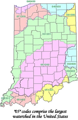
Knowing your “watershed address” is very important to understanding the influences on the water quality in your stream or river. Delineated by the U.S. Geological Survey, hydrologic units represent the geographic boundaries of water as it flows across the landscape. Indiana is divided into 39 watersheds at the 8-digit level. Each of these watersheds can also be divided into smaller sub-watersheds which are represented by 11-digit numbers, and even smaller units with 12– digit numbers.
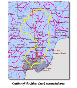
Silver Creek Watershed
05140101-140
What does the 11 digit code tell us about the watershed?
05 – watershed flows into the Wabash or Ohio rivers before joining the Mississippi River (largest watershed in the US)
051401 – Ohio River Basin
05140101 – Silver – Little Kentucky Watershed
05140101140 – Silver Creek Watershed
Knowing your “watershed address” is very important to understanding the influences on the water quality in your stream or river. Delineated by the U.S. Geological Survey, hydrologic units represent the geographic boundaries of water as it flows across the landscape. Indiana is divided into 39 watersheds at the 8-digit level. Each of these watersheds can also be divided into smaller sub-watersheds which are represented by 11-digit numbers, and even smaller units with 12– digit numbers.
Silver Creek Watershed
05140101-140
What does the 11 digit code tell us about the watershed?
05 – watershed flows into the Wabash or Ohio rivers before joining the Mississippi River (largest watershed in the US)
051401 – Ohio River Basin
05140101 – Silver – Little Kentucky Watershed
05140101140 – Silver Creek Watershed
 |
 |
